Subscribe To Beau Dodson Weather
WeatherTalk App
Receive Beau Dodson's personally crafted and written alerts directly to your phone, plus gain access to BDW digital media blog. Completely tailored weather products for all situations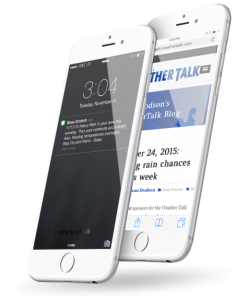

Beau’s exclusive, real-time weather notifications
WEATHER TALK APP
Whether you are a teacher, coach, parent, farmer, or just need to know the forecast for your weekend plans, Beau Dodson Weather has tailored weather products for all situations.
When severe and winter weather hit, there’s no time to delay. Give yourself and your loved ones the gift of advanced warning and detailed forecasts, customized to your area. A simple notification could mean all the difference in the world!
Notice of Severe Weather and Winter Storms Approaching
These are possibly the most important messages to receive. Get updates from Beau before and during significant weather events. Even when the television signal goes out or you’re away from home, Beau will be there.
Daily Weather Updates
Wondering how to dress for the weather? Thinking of having a barbecue tonight? Wondering if there’s snow and ice heading your way? Beau knows, and he’s got you covered!
Social Media Notifications
Receive an immediate notification when Beau makes important posts about severe weather and winter storms on his Facebook page and WeatherTalk blog.
Beau Dodson Weather Talk APP
TAILORED CONTENT
Personal Notifications
sent directly to your phone. Beau Dodson is making it easier than ever to stay on top of the weather that matters most to you.
Continuous Eye On Weather
will work to let you know where severe weather was last spotted in your area.
Unlike Weather Apps
that rely on computer-generated predictions, this app service is like having a direct link to one of the area’s best meteorologists.
Convenient App Messages
work to supplement and expand upon the standard alerts you likely receive from the National Weather Service, including those warning of severe weather events in your area.
Weather Notifications
can be sent to up to five phone numbers.
Keep Your Loved Ones Safe
and alert by providing them with this invaluable gift! No one should be left to weather the storm alone. Beau’s exclusive, real-time weather notifications are powered by The Fire Horn.
Beau Dodson – Weather Services
Tools, Content & Merchandise
At Beau Dodson Weather, we are dedicated to keeping you informed and prepared for all weather conditions. Our comprehensive suite of services ensures you have the most accurate and up-to-date weather information right at your fingertips!


Beau Dodson – Social Feeds
Facebook, Twitter, Instagram & Youtube
Genuine Connections: Forge new friendships and view the latest weather information along side like-minded individuals from across the region.


Beau Dodson Weather
When the weather becomes personal! Beau Dodson is a degreed broadcast meteorologist. Bachelor of Science degree. Serving southeast Missouri, southern Illinois, western Kentucky, and northwest Tennessee.

YouTube

Threads

